Cities of the Future: Towards Technical or Natural Optimisation?

Amanda Erickson put up a nice, simply visualisation of what life might be like in a future of driverless, automated cars. Check it out.

[vimeo http://vimeo.com/37751380]

Two things sprang to mind while watching this – first, how terrifying this might be for a passenger in one of these cars, and second, haven’t I seen this sort of thing somewhere else before?

Well, yes, I showed the following video in a lecture last month as demonstration of self-organisation.  To me, the patterns look similar – at the higher level you see chaos, but when you observe the actions of individual’s there is usually a rational stream of thought behind the actions they are taking – normally to get to their exit road.  Judge for yourself.

[youtube http://www.youtube.com/watch?v=mr5Gssaxl6g&version=3&hl=en_US]

I think the stark similarity seen between these two videos raise interesting questions about what we consider as progress in the urban realm.  Bare with me as I attempt to explain.

The driverless or automated car is often seen as the natural future of private transportation*, with one of its main benefits being the apparent offer of optimal organisation of traffic flows (e.g. no congestion).  And indeed when look at the first video, everything works and works well, perhaps even optimally.  But then you look at the second video, and you essentially have the same thing, created solely through the activity of individuals.

It is strange therefore that a fully optimised technical system is generally deemed necessary and superior.  When people are left to their own devices, to ‘sort it out between them’, people invariably do.  Traffic in Hanoi is not just the only example of this type of self-organisation – the Internet itself is a creation of human ingenuity.  Following Monderman’s ideas on Shared Space, perhaps all of these traffic regulations, signage and restrictions actually reduce our need to think about what we are doing.  They reduce and remove our ability or will to self-organise, and to the deficit of us all.

So why don’t ‘natural’ answers to technical problems receive a better press?  I suspect it is an issue of trust in the citizen.  That threat that one person may mess up, and mess it up for the rest of us.  Instead of facing the risk and accepting it as part of the solution, we surround ourselves with unnecessary and invasive mechanisms that carry out the task for us.  They may cost a lot of money and not be any better than our current solution, but they feel like progress.  It feels like things are getting better.  So, yes, perhaps automated cars are indeed a thing of the future.

As ever, very interested to hear your thoughts on this.

* I’ve personally never been so sure – mainly because of the safety element, and that fact that many people actually enjoy the process of driving…


London Driver Survey

As part of building a fuller understanding of the way people move around the city by car, I’ve developed a survey to start delving into some of the lesser understood issues.

The survey looks at the extent of use of GPS and similar devices, behaviour around congested areas of the network and usage of traffic information.  The results will contribute towards the building of a better model of driver behaviour.

You can find the survey here – http://goo.gl/UDrFI

Please pass it on to all of the motorists in London that you know!

Agent-based Modelling + Traffic Flow Modelling = Large-Scale Urban Simulation

At the upcoming AAG conference in New York, I’ll be presenting a recent prototype that links agent-based simulation with current traffic flow models.

The basic premise is that any cognitive decision associated with movement around cities should be modelled at the level of the individual.  However, it is not always necessary that all movement be represented individually.  Doing so potentially wastes limited computational power, especially important where modelling many complex agents.

Instead, my new simulation utilises traffic flow modelling to constrain the movement of individual agents.  Individuals choose where they move individually, but physical movement itself is modelled collectively.  The higher the traffic flow on a single route, the slower each agent on that route will travel.  This approach is more efficient and allows a much larger scale of complex agent-based simulation.

I’ll provide more detail at AAG next Sunday, but the basic result is as above.

The simulation demonstrates traffic flows across central London.  There are 30000 agents of varying behavioural characteristics moving around this space.  Their movement decisions impact on the state of the network.

[vimeo https://vimeo.com/36979205]

KEY:  The redder colours represent high traffic saturation aka queues and congestion, the blues and greens represent quiet or free flowing traffic conditions.


Mapping Taxi Routes in London

One major aspect of my research is spent looking into how people choose their routes around the city.  And to aid me in this, I managed to acquire a massive dataset of taxi GPS data from a private hire firm in London.  I’ve spent the last few months cleaning up the data, removing errors, deriving probable routes from the point data and extracting route properties.

It’s been a big job, but worth it.  I now have the route data of over 700,000 taxi journeys, from exact origin to destination, over the months of December, January and February 2010-11.  I’m now moving on to the actual analysis of this data, and am beginning to answer some of these questions concerning real-world route choice.  In the meantime, I thought I’d share one striking image that I extracted through this work.

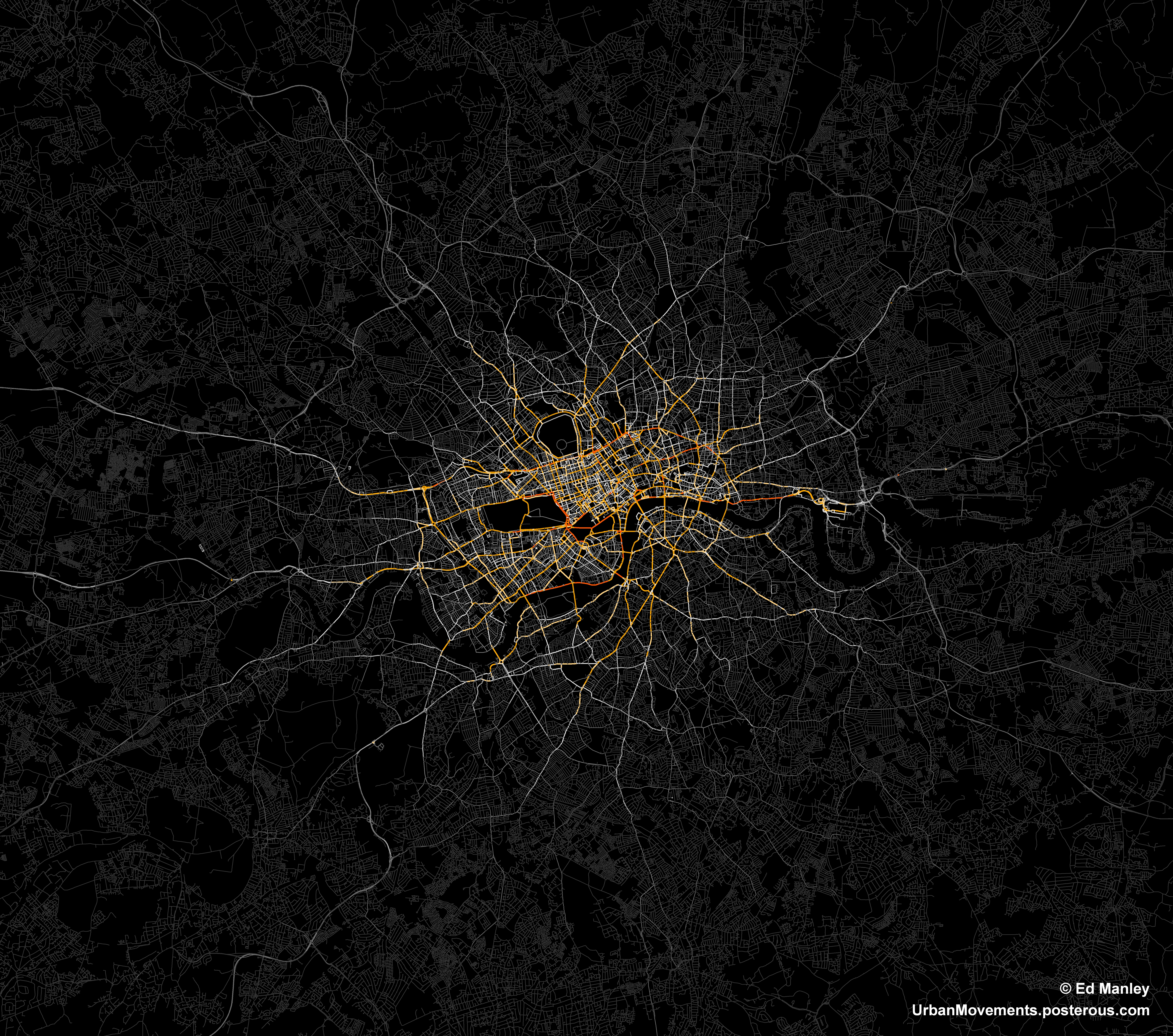
The image below represents an aggregate of journeys on each segment of road on the London road network.  The higher levels of flow are illustrated in red, falling to orange, yellow, then white, with the lowest flow values shown in grey.

The most popular routes are along Euston Road, Park Lane and Embankment, which may be somewhat expected, but make for a stark constrast with respect to the flow of most traffic in London.  The connection with Canary Wharf comes out strongly, an indication of the company’s portfolio, though route choice here is interesting with selection of the The Highway more popular than Commercial Road.

Real insight will come with the full analysis of the route data, something that should be completed in January.  Until then, though, I’ll just leave you with this pretty something to look at.

The Madness of Crowds – London Edition

‘The Madness of Crowds’ was a book written by Charles MacKay in 1841, describing the formation of crowd behaviours such as hysteria, economic bubbles and mass panic.  MacKay was among the first to begin to describe widespread phenomena that exist beyond the realm of individual rationality, phenomena that only exist through the interaction of crowds.  One particularly prescient quote may be as follows:

“Men, it has been well said, think in herds; it will be seen that they go mad in herds, while they only recover their senses slowly, and one by one.”

It appears to me that, in trying to understand and explain what has happened in London over the last few days, the press and politicians have forgotten this basic principle of crowd behaviour.

We all know that rioting and looting is a criminal activity (thanks for pointing that out Nick Clegg and Boris Johnson), but it is now taking place within an environment of acceptance and normality, an environment that has developed extremely quickly.  Within these social networks, existing across the intertwined ‘real’ and online worlds, there persists an ongoing idea, for whatever reason, that this behaviour should be taking place.  This is clearly dangerous and irrational, but it is an idea that remains.  Instead of calming the situation, I suspect that the threat of heavy policing and criminal prosecution is inflammatory, riling the crowd and encouraging them to go to further lengths.

In trying to understand these situations, people look to establish the drivers of this behaviour – the shooting that prompted the anger, or Twitter being used a platform for communication.  But this misses the point.  Rioting doesn’t need a cause, it is an irrational herding behaviour, where new norms are established quickly.

The ending of this behaviour must come from the base up.  Individuals – probably many of whom are normally decent and functioning members of society – must realise for themselves that what they are doing is wrong.

Unfortunately, this realisation, with the supporting infrastructure of online social networks maintaining this irrationality, may come later rather than sooner.

From Road Closure to Road Congestion

Much of my work attempts to recreate the macro from the micro.  That is the explanation of large-scale effects through the examination of small-scale behaviours.  I look at how these develop over space and time.

So, more specifically, I look at how road congestion forms in cities and how we, as travellers, all contribute towards it.

As part of my early work on this stuff, I developed a simulation looking at how traveller decisions impact on the flow of traffic in adverse situations.  This consisted of the development of an Agent-based Model (ABM) using the Java-based Repast Simphony framework.  After a fair bit of faffing with Repast (which, I should add, is great although has a considerable learning curve in comparison to some ABM software), I have a model that demonstrates the impact of road closures across a population of driving agents.

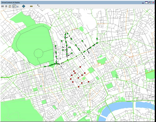
The video below shows how the population of individually-cognating agents move from an area of origins (in green) to an area of destinations (in red) through London.  All of the agents move through geographic space, specifically an area around UCL in Euston.  So, this first video shows the normal situation, the next video will show how that changes once we mess things up a bit. (By the way, the video takes a few seconds to get moving, just allowing me a few seconds of in-lecture explanation).

Although the model is relatively simple in traffic simulation terms (with no traffic lights and regulations etc), I think it does show where concentrations of traffic form.  Particularly through the Euston Road/Tottenham Court Road junction.  So, what would happen if we closed this junction?  This…

I think it’s interesting to see the redistribution in traffic around the network.  Knowing that this junction is closed, you get a lot more movement along other roads suggesting that traffic would be considerably slower in these areas.  Clearly, the exact where’s and when’s in this scenario are some way of what reality might show.  Not only do we not have the impact of road regulations, but each individual holds a perfect knowledge of the network, proceeds towards their target along the shortest path and has prior knowledge of the closure ahead.  These are three important aspects I address in other pieces of work that I’ll put up later.  I also realise a bit of flow data would be quite useful here, but considering the pure conjecture of this scenario I’m not sure it’ll add much!